


Research: Extreme-rain-producing mesoscale convective systems
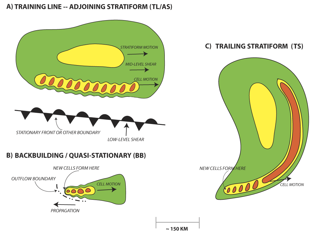
One of Dr. Schumacher's first research projects, which still provides questions that motivate ongoing work, was to examine radar observations of a large number of extreme rainfall events in the eastern 2/3 of the United States. The goal of this work, which was done with Richard Johnson of Colorado State University, was to determine how heavy-rain-producing convection is organized, how it moves, and where and when it most frequently occurs. We considered events that exceeded the 50-year recurrence interval for 24-hour rainfall accumulation at one or more gauges. In the total five-year sample, which comprised 184 events, we found that 66% of all events, and 74% of warm-season events, were associated with mesoscale convective systems (MCSs). These MCSs were classified by their organizational structures, and three patterns of organization were observed most frequently. These were termed "Training Line/Adjoining Stratiform" (TL/AS), "Back-building/Quasi-stationary" (BB), and a special case of the trailing stratiform (TS) pattern where there are training echoes along the southern end of the line. These three types are shown in this schematic:
Refereed publications on this subject
- Schumacher, R. S., and R. H. Johnson, 2005: Organization and environmental properties of extreme-rain-producing mesoscale convective systems. Monthly Weather Review, 133, 961-976.
- Schumacher, R.S., and R.H. Johnson, 2006: Characteristics of United States Extreme Rain Events During 1999-2003. Weather and Forecasting, 21, 69-85.
- Schumacher, R.S., 2009: Mechanisms for Quasi-Stationary Behavior in Simulated Heavy-Rain-Producing Convective Systems. Journal of the Atmospheric Sciences, 66, 1543--1568.
- Keene, K.M., and R.S. Schumacher, 2013: The bow and arrow mesoscale convective structure. Monthly Weather Review, 141, 1648-1672.
- Peters, J.M., and R.S. Schumacher, 2014: Objective categorization of heavy-rain-producing MCS synoptic types by rotated principal component analysis. Monthly Weather Review, 142, 1716-1737.
- Stevenson, S.N., and R.S. Schumacher, 2014: A 10-year survey of extreme rainfall events in the central and eastern United States using gridded multisensor precipitation analyses. Monthly Weather Review, 142, 3147-3162.
- Peters, J.M., and R.S. Schumacher, 2014: Mechanisms for organization and echo training in a flash-flood-producing mesoscale convective system. Monthly Weather Review, in press.