Research: Mesoscale convective vortices (MCVs) and their relationship to precipitation
The latent heating in a large complex of deep moist convection will often produce a cyclonic vortex at midlevels---generally known as a mesoscale convective vortex (MCV). If the conditions are right, these vortices can then go on to initiate additional convection the next day. As a result, they represent a complex forecast challenge: for a numerical model forecast to make an accurate "day 2" forecast, it must make a correct prediction of the location and timing of the convection on day 1 (which is itself difficult); it must represent the vertical structure of latent heating that leads to the development of the MCV; it must correctly capture the evolution of the vortex; and it must determine whether the lifting associated with that vortex will initiate convection again.
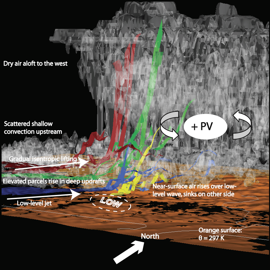
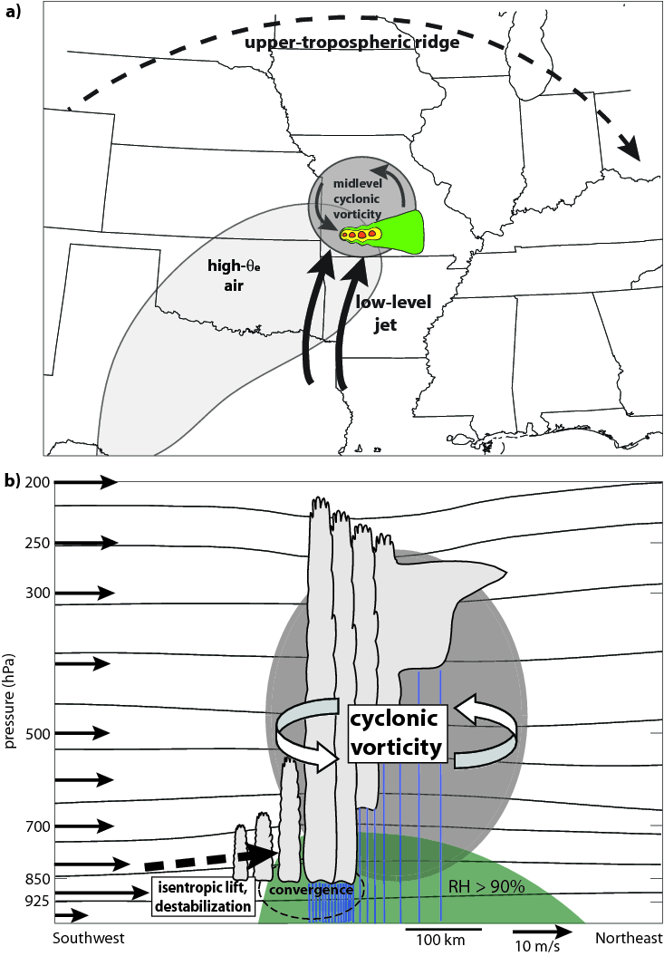
In some cases, the "day 2" convection that develops moves slowly and produces excessive amounts of rain. Numerous factors contribute to the favorable environment for heavy rain near MCVs: the atmosphere is usually very moist, which itself leads to efficient precipitation; the vortex circulation provides lifting and destabilization on the downshear side; the relative humidity is high, so there is little evaporation of rain; the lack of evaporation inhibits the development of strong cold pools (which tend to make convection move faster); and the winds are usually weak in the midtroposphere, which means that everything moves relatively slowly. In particular, when a strong low-level jet intersects the vortex, there is enhanced lifting, a source of moisture, and increased convergence, which can lead to quasi-stationary, heavy-rain-producing MCSs.
These processes have been summarized, through the analysis of observations and numerical simulations, in the figures below. The first is a 3-D visualization of an extreme-rain-producing MCS that occurred on 6--7 May 2000 in Missouri. The second is a schematic diagram based on composite analysis of several MCV-related heavy rain events.


Refereed publications on this subject
- Schumacher, R. S., and R. H. Johnson, 2008: Mesoscale Processes Contributing to Extreme Rainfall in a Midlatitude Warm-Season Flash Flood. Monthly Weather Review, 136, 3964--3986.
- Schumacher, R.S., and R.H. Johnson, 2009: Quasi-Stationary, Extreme-Rain-Producing Convective Systems Associated with Midlevel Cyclonic Circulations. Weather and Forecasting, 24, 555--575.
- Schumacher, R.S., 2009: Mechanisms for Quasi-Stationary Behavior in Simulated Heavy-Rain-Producing Convective Systems. Journal of the Atmospheric Sciences, 66, 1543--1568.
- Schumacher, R.S., 2011: Ensemble-based analysis of factors leading to the development of a multi-day warm-season heavy rain event. Monthly Weather Review, 139, 3016-3035.
- Schumacher, R.S., A.J. Clark, M. Xue, and F. Kong, 2013: Factors influencing the development and maintenance of nocturnal heavy-rain-producing convective systems in a storm-scale ensemble. Monthly Weather Review, 141, 2278-2801.


